New tool provides data on statewide flooding; Kanawha County has high critical infrastructure flood risk
By Autumn Shelton, RealWV
CHARLESTON, WV – On Tuesday, members of the Joint Legislative Committee on Flooding watched a demonstration of the West Virginia Resiliency Framework developed by those at the GIS Technical Center at West Virginia University. The framework was designed to help community leaders identify flood risks throughout the state, including critical infrastructure that may be damaged by floodwaters, and help the state better prepare for flood emergencies.
On hand to demonstrate how the free online site works were Kurt Donaldson, manager of the GIS Technical Center, and Dr. Behrang Bidadian, research associate and certified floodplain manager.
According to Bidadian, one important mission of the GIS Technical Center and the West Virginia Flood Resiliency Framework is to support statewide disaster resiliency based on data in the West Virginia Risk Explorer.
“We have conducted community engagement efforts with focus group meetings, a couple of flood symposiums, last year and this year, and some products such as the best practices guide and detailed risk reports,” Bidadian said. “We have been developing the West Virginia Hazard Library, which is a comprehensive source of all data, documents and media we could collect, or generate, related to flood risk.”
Stakeholders who will most benefit from the framework include local and state officials as they develop flood hazard mitigation plans, according to Bidadian. It includes flood risk assessments tools, mitigation assessment tools, risk communication tools and the hazard library.
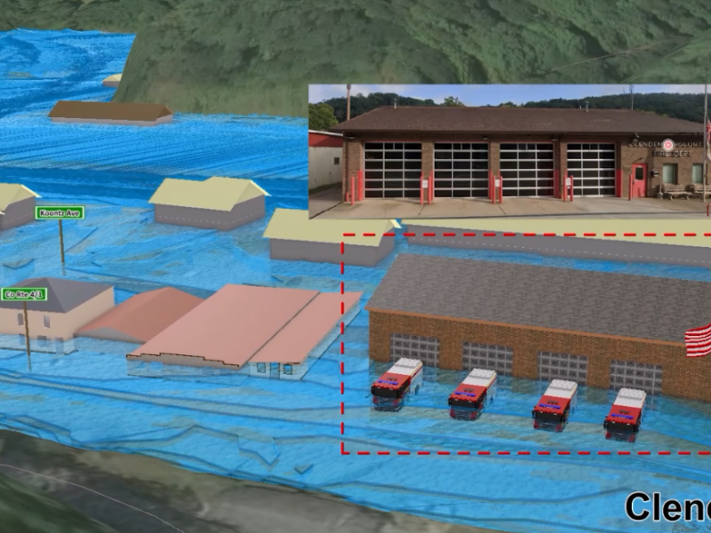
“We have mapped all primary structures in FEMA’s 100-year floodplain in addition to community assets . . . and essential facilities . . . in both 100 and 500 year floodplains,” Bidadian continued, adding that the data is aggregated into multiple scales from data on a state level down to incorporated and unincorporated areas. Individual properties may also be searched to determine their flood risk.
“From these scales, we developed a West Virginia Flood Index . . . and calculated risk scores for each entity,” Bidadian said.
The Data
According to data found in the West Virginia Risk Explorer, there have been a total of 65 federally-declared flood disasters in the state since 1953. Mingo County has seen the highest number of federally-declared flood disasters in that time with a total number of 28.
West Virginia has 528,000 acres of floodplain, which is equivalent to 3.4% of the state’s area. Hampshire County has the largest floodplain area in the state followed by Kanawha, Mason, Greenbrier and Randolph counties.
In Boone County, the town of Sylvester has the highest portion of its area (79.4%) located within a floodplain.
82,408 primary (insurable) structures (7.4% of all structures) statewide are located in a floodplain. The total value of all these structures amounts to over $10 billion. Kanawha County contains the most structures in a floodplain at 13,452. Statewide, a total of 8,237 primary structures are located in a floodway (a main channel of a river or stream). Kanawha County has the most primary structures located in a floodway (1,462) followed by Logan County (961).
In addition, the state has 489 essential facilities, such as hospitals, fire departments, police departments and schools, located in a floodplain. Statewide totals include the following:
- 187 fire departments
- 170 schools
- 88 police stations
- 19 nursing homes
- 15 hospitals
- 10 E-911 emergency operations centers.
Kanawha County has the highest number of essential facilities located in a floodplain with 80 facilities, followed by McDowell County with 32 facilities.
There are also 2,758 historical assets and 2,092 non-historical community assets throughout the state located in a floodplain.
198,888 of the state’s residents (11%) live in high risk floodplains. McDowell County has the most residents living in a floodplain at 45%, followed by Boone County at 37.5%.
More information about the West Virginia Flood Resiliency Framework
According to a June 2025 release from WVU, “flood and natural hazard risks are high in West Virginia compared to other areas, due to steep topography, a humid climate and weak geologic strata in places where landslides are likely to occur. West Virginia has one of the highest per capita inland riverine flooding and landslide rates in the nation.”
Aaron Maxwell, faculty director of the GIS Technical Center was quoted as saying, “We’re in a unique situation, I think, to need these types of tools (the Flood Resiliency Framework), because they are real problems. And a lot of people live in the floodplain because that’s just where the flat land is, especially in the southern part of the state. It’s basically steep hillsides and floodplains, and it’s not easy to move out of the floodplain, either.”
All 55 West Virginia counties have a high level of risk for flooding,” the release continues. “The state lacks a long-term flood recovery plan and, as such, its response to floods has been inefficient.”
Bidadian concluded his presentation to members of the flooding committee by stating that the GIS Technical Center is working on continued updates to the Flood Resiliency Framework, including updates to the hazard library.
Additionally, he stated that they are seeking additional funding to keep the information updated.